Saturday, September 29, 2012
Monday, September 24, 2012
Calf Creek Falls Trail
I don't know what I was thinking. But had heard about this hike and heard that it wasn't too taxing - moderate. I do 4 mile hikes easy so a 2.7 hike to and 2.7 back didn't seem like much - although I knew there would be some climbing.
Everything started out really well.
This is actually the view of Calf Creek Falls, as you enter the park and trailhead area.
There are always interesting rocks and formations and erosion in this area. Here's an arch sort of erosion.
Another beautiful wall.
And here this lizard just seemed to pose for Walt and his camera.
Some grafitti left by folks here before (Walt and I speculate that this is ancient Femont type grafitti for "John loves Marry"!!!!!)
All of this culminated in the final reward - this wonder falls and it was wonderful - it was cool - and it was beautiful. What made it even more fun, was to realize that on the way out back to the trail head, that my struggle to get to the falls was because we were on a slow incline, and the whole trail back was a slow decline - thank heavens, my thighs were twitching when I got home that night, but made up for it by eating half a cartoon of ice cream!!!!
Everything started out really well.
This is actually the view of Calf Creek Falls, as you enter the park and trailhead area.
But we passed some pretty desolate landscape to get to Calf Creek. No one could grow anything here and yet there were cattle guards about every 5 miles or so.
When we first entered the hike we spotted a hawk checking over his side at the airplane!!!
There are also the most remarkable faces on these rocks.
Another beautiful wall.
And here this lizard just seemed to pose for Walt and his camera.
Some grafitti left by folks here before (Walt and I speculate that this is ancient Femont type grafitti for "John loves Marry"!!!!!)
All of this culminated in the final reward - this wonder falls and it was wonderful - it was cool - and it was beautiful. What made it even more fun, was to realize that on the way out back to the trail head, that my struggle to get to the falls was because we were on a slow incline, and the whole trail back was a slow decline - thank heavens, my thighs were twitching when I got home that night, but made up for it by eating half a cartoon of ice cream!!!!
Friday, September 21, 2012
The Pipes of Kodachrome State Park
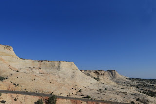
We made an early-morning visit to this Utah state park, and one of the major features of the parks are the spires or pipes. You know these things stand out like they do elsewhere in the canyons of Utah, and I assumed they were formed the same way like the Hoodoos in Bryce, but not so.
Of course if you're a crow, the best way to tell everyone is on one of the highest spots!
Known as the ballerina pipe.
I call this one "the monK"
And there's always a hat pipe.
They have an even more fascinating beginning.
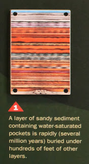
First you start out with a whole bunch of sediment laid down very quickly. Remember this is geological terms and quickly for geology is a couple of million years.
Then you have this gooey stuff that's forced up from the base layer of soil.
So it makes it to the top.
And then you have this long channel of gooey stuff that's finally happy cause it's reached the top....but, it's not finished.
Now some more topped off with more quickly laying sediment and this makes it into a very hard rock.
So that when the erosion starts, all but the stuff that was once gooey is now....wait for it...."hard as a rock!" (Bad joke!)
So then what happens is that the wind and water eventually erode all but the pipe and voila - just like that you're left with a spire which of course took only a gazillion years! But nevertheless very fascinating.
All of these photos are courtesy of the Visitor's Center at Kodachrome State Park, Utah.
See more of our photos on our gallery.
Of course if you're a crow, the best way to tell everyone is on one of the highest spots!
Known as the ballerina pipe.
I call this one "the monK"
And there's always a hat pipe.
They have an even more fascinating beginning.
First you start out with a whole bunch of sediment laid down very quickly. Remember this is geological terms and quickly for geology is a couple of million years.
Then you have this gooey stuff that's forced up from the base layer of soil.
So it makes it to the top.
And then you have this long channel of gooey stuff that's finally happy cause it's reached the top....but, it's not finished.
Now some more topped off with more quickly laying sediment and this makes it into a very hard rock.
So that when the erosion starts, all but the stuff that was once gooey is now....wait for it...."hard as a rock!" (Bad joke!)
All of these photos are courtesy of the Visitor's Center at Kodachrome State Park, Utah.
See more of our photos on our gallery.
Monday, September 17, 2012
Slot Canyons
We had a great day of canyon-ing (is that a verb - oh well it is now!)
Canyon-ing in So. Utah means slot canyons....and they are a blast. The
rain and water and wind erodes certain layers of the soil (not dirt,
dirt is something you sweep out of your home!), and therefore some
layers of soil stay (are harder to erode) while other layers wash away
with the water.
But one bad thing happened. We traveled most of the creek today with
another couple from Colorado. You can see them here in the bottom of
this shot.
They were lovely and we promised to leave our contact info. However, on the way back to the car, Claire was attacked by a cactus (and she was just minding her own business - promise!) and the cactus won. So being the artist and always aware of her fingers and hands and keeping them in as agile condition as possible, became very worried about all the prickly-thingies sticking out of her hand. So leaving a name & contact info became, get me back to the RV now so I can get these flaming sticky things out of my fingers moment! Not until we were back in Cannonville, did we remember that we hadn't left a note one. Alas, hopefully they can see the blog or our site, and hopefully find us that way!
Here is Willis Creek waterfalling into the wash that is going to lead to the slot canyons on further downstream.
Most slot canyons have washes or creeks through them, and as the area
had, had a goodly amount of rain recently we had seen a lot of roads
washed out on the road to Willis Creek. But once there we were treated
to a fine show. These are some of the spectacular photos from Walt's new Canon that
really capture the swirls and movement on the slot canyon walls. I'm continually fascinated by the colors and the designs the water
makes; ridges so perfectly formed, you think someone came through with
an intricate Dremel drill!
They were lovely and we promised to leave our contact info. However, on the way back to the car, Claire was attacked by a cactus (and she was just minding her own business - promise!) and the cactus won. So being the artist and always aware of her fingers and hands and keeping them in as agile condition as possible, became very worried about all the prickly-thingies sticking out of her hand. So leaving a name & contact info became, get me back to the RV now so I can get these flaming sticky things out of my fingers moment! Not until we were back in Cannonville, did we remember that we hadn't left a note one. Alas, hopefully they can see the blog or our site, and hopefully find us that way!
Wednesday, September 12, 2012
Three days of the Condor....
Out in Page, AZ today and we were messing around Horseshoe Bend and there was no light....we brought a line a storms in when we came into town, and this morning the clouds still hadn't cleared out, so we thought we would trek south to photography Marble Canyon and other beautiful sights around there.
You know sometimes when you have a picture that appeals to you for one reason or another and you keep it on the icebox door, or bulletin board or desktop to remind you of places you want to go? Well the Navajo Bridge across the Colorado River reminded me just of that. So when I took my own picture, I was specific about what I wanted and voila - I got it.
These are the beautiful Vermillion Cliffs just past the Navajo Bridge, and although the bridge is not well lit by the sun, we were just so happy to have any Sun, that the cliffs looked fabulous.
While there on the bridge, we began to notice a large vulture like bird, but it was larger than a vulture and not the right markings. Suddenly it occured to both of us that the bird is a condor - we had lucked into about 3 California Condors and Walt took some remarkable shots.
They may not be the most beautiful of birds, but they are fascinating up close and HUGE.Frankly, this one looks like a Halloween Costume!
Flying is something they do very gracefully and I love the "fingers" on the edge of their wings.
All of the Condors are numbered as this is an endangered species, however they are making a comback and one of the places that is normal to see them is over the Colorado River near the Navajo Bridge and the Vermillion Cliffs.
We did return to Horseshoe Bend to get the sunlit shot of the "U" in the river.
It is hugely dramatic....there is probably an 800 to 500 foot drop off (what's a few 100 feet or two on a drop off - anything more than 4 feet and I'm afraid I would be a mess of bones!) Standing on the edge is very unnerving, but the scenery is really gorgeous especially this time of year.
Subscribe to:
Comments (Atom)


